| Tropical Depression (SSHS) | |
|---|---|
| Formed | October 30, 2013 |
| Dissipated | November 1, 2013 |
| Damage | $1.5 billion |
Tropical Depression 13 was the thirteenth and deadliest tropical cyclone in the 2013 Atlantic hurricane season. The system was infamous for its mass destruction and fatalities it caused. A grand total of 347 fatalities were reported throughout Louisiana and Mississippi. It also flooded major sections of the New Orlans parish from a severe storm surge although a 5.8 magnitude earthquake over the southeastern Gulf of Mexico was partially responsible for the catastrophic damages.
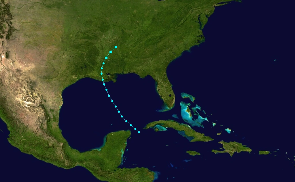
Initally forming over the northwestern Carribean Sea as a tropical wave, the system absorbed nearby moisture from a scattered group of subtropical weather. The system gradually developed while moving over the Loop Current, forming an organized symmetric spiral shape and closed low-level circulation. By October 30, the National Hurricane Center classified the system as Tropical Depression 13 while hovering over the central Gulf of Mexico. By the evening of October 31, the depression made landfall near Terrebonne, Lousiana with maximum sustained winds of 35 mph (55km/h). It quickly degenerated into a remant after landfall and dissipated over eastern Louisiana on November 1.
Storm history[]
Storm history
A tropical wave formed off the African coast on October 17. It slowly tracked across the Atlantic Ocean, crossing the Leeward Islands on October 26. There, the system encountered more favoritable conditions despite the fact of its poorly organized center and with moderate vertical shear south to the system. The system began to absorb moisture wandering across the Greater Antilles. Satellite images began to show an asymmetrical spiral shape across the system while it was passing by an upper-level low northeast to the system. On the evening of October 28, a sudden yet tremendous amount of convection formed around most of the circulation with a low-level circulation was forming. Forecasters at the National Hurricane Center expected the system to eventually develop a cloased circulation and intensify over the Gulf of Mexico with 2 to 3 days. By October 29, when the system had significantly organized, it yet lacked a central pressure center although approxiametly 12 hours later, the National Hurricane Center designated the system as Tropical Depression 13.
The depression continued its path over the Gulf, predicted to hit the southern Louisiana coast. Forecasters issued out tropical storm warnings and watched for the eastern half of the Louisiana coast. Unexpedictly, the depression almost doubled in size, forcing NHC forecasters to extend the warnings to most of the Lousiana coast and the Mississippi coast. The forecast also expected the storm to attain tropical storm-force winds shortly before landfall. On the evening on Friday, October 31, the depression made landfall on the Terrebonne county with maximum sustained winds of 35 mph (55 km/h) without strengthening into a tropical storm. The depression quickly began to weaken and produced torriental rainfall and precipation throughout southeastern Louisiana. The system dissipated shortly thereafter and degenerated into a remant low over eastern Louisiana by November 1. The remants continued into northern Mississippi before it was absorbed by a cold front whilst over Tennesse.
Preparations[]
The National Hurricane Center issued advisories six hours prior to the storm's landfall warning residents no to stay outside within the projected area of the storm's path and to remain inside a building at all times. New Orleans mayor Semyour S. Charlmers also encouraged residents to stay in a sheltered building at high ground if possible. One unofficial weather report from a bouy about 6 miles off the Louisiana coast reported maximum sustained winds of 45 mphs, although there was no confirmation to the report.
Impact[]
Louisiana[]
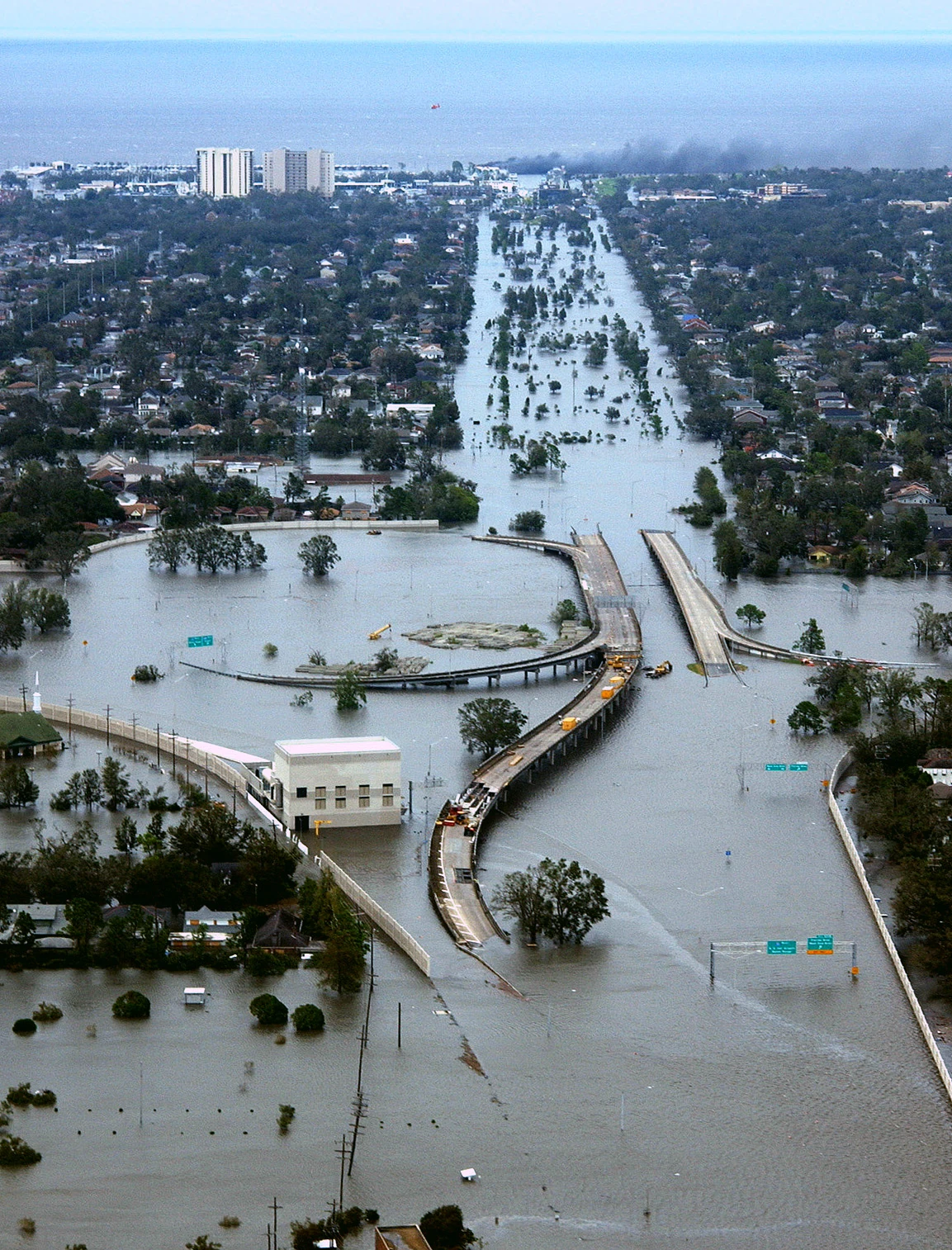
Flood in New Orleans caused by Tropical Depression 13.
Louisiana suffered several of the worst impact as New Orleans was flooded by a severe storm surge partial caused by the storm, while a rare 5.8 magnitude earthquake over the Gulf Stream was also thought to have intensified the strength of the storm surge. The Lower Ninth Ward was quickly flooded by the raging waters as the surge formed a crack in the levees, causing a hole for the water to seep in. A total of 132 people were reported to have died within and around the Greater New Orleans metropolitan area. An maximum estimated 8.2 inches of rain was reported over Iberville, Louisiana while an unconfirmed report indicated a spectator witnessing a waterspout located off the coast of the western Lake Pontchatrian.
Flooding which was the primary issue, caused an estimated $1 billion in damage along with major power outages and severe precipation. Schools across the affected area declared a storm event and was closed for the next 2 weeks until it district declared it safe enough to resume school. Hundreds of other businesses were destroyed or suffered from severe damages, particularly in the low-lying regions where flood waters was severe enough to wash out an entire bridge. One transformer was broken by lighting strikes to it causing a minor brownout throguhout St. Francisville, Louisiana.
Several marishes off the southern Louisiana coast were also heavily flooded from the storm surge. A satellite image also showed the Mississippi River delta flood into Lake Pontchatrian and the Barcariaria Bay. Extensive damages to major cities across the Greater New Orleans area made Louisiana governor, Lionel J. Hibbert declare the area a federal and state disaster. FEMA responded by sending off its aid to the affected area by November 3, helping people to evacuate and find missing people. US President Al Gore stated that "New Orleans has suffered yet, another natural disaster since Hurricane Katrina to greatly affect not only the entire city, but the nation as well."
Mississippi[]

An EF3 tornado seen obliterating the city of Idianola, Mississippi.
The remants of the storm produced precipation with up to 5.5 inches of rain reported from Vicksburg, Mississippi. One verified report claimed an EF1 tornado near Belzoni. Three fatalities were thought to have been associated with the tornado. Another report included an EF3 tornado devastaing the entire town Idianola with a total of 76 fatalities and 142 injuries.
Severe precipation from the storm caused the Mississippi River to dangerously overflow its banks, flooding parts of Greenville, Mississippi. Twenty-two people were reported to have drowned from the strong flow of the flood while a 13 year-old girl was reported to have drowned in a riptide. Additionally, 32 people were killed when a building collapsed after its internal structure failed to support its own weight.
Numerous of homes were reported to be partially submerged in Natchez due to the flooding of the Mississippi River. There, are fallen tree was to have crashed onto a house injuring two people inside. Additionally power outlets were reported throughout several counties throughout western Mississippi while a major blackout at Greenville was reported to cut off 35,000 customers.